Buangkok Forest is a pocket of wild green tucked between the housing estates of northeast Singapore. Step onto its trails and the city fades quickly: wide dirt paths turn muddy in places, the air grows cooler and heavier, and the hum of traffic gives way to birdsong and rustling leaves. It feels far less manicured than the park connectors I usually hike, and that’s exactly its charm.
For hikers looking for a quieter, rawer side of the island, Buangkok Forest is a welcome surprise. Snakes and muddy shoes included.
Table of Contents
My Hike Today through Buangkok Forest and Sungei Serangoon Park Connector
Here’s a google map of my 10km hike today.
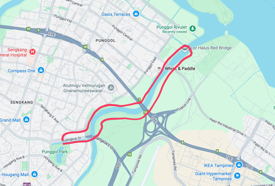
Yes, I am doing a whole loop today. So no grab PHV needed 🙂
Where I Parked to start the Hike
There are a few ways but what I did was to park at Punggol Park. There is a small car park at Punggol Park which can get busy in the mornings.

The car park is next to the excellent Tenderbest Makcik Tuckshop (if that is NOT enough incentive for you to finish your hike there) 😋

How to Get to Buangkok Forest
From Punggol Park, I walked inside the Park to reach Buangkok Drive. Note that you dont have to leave the Punggol Park. You are just walking along the path. This is the route shown on my google map but dont leave the Punggol Park. Walk the red line at the top.
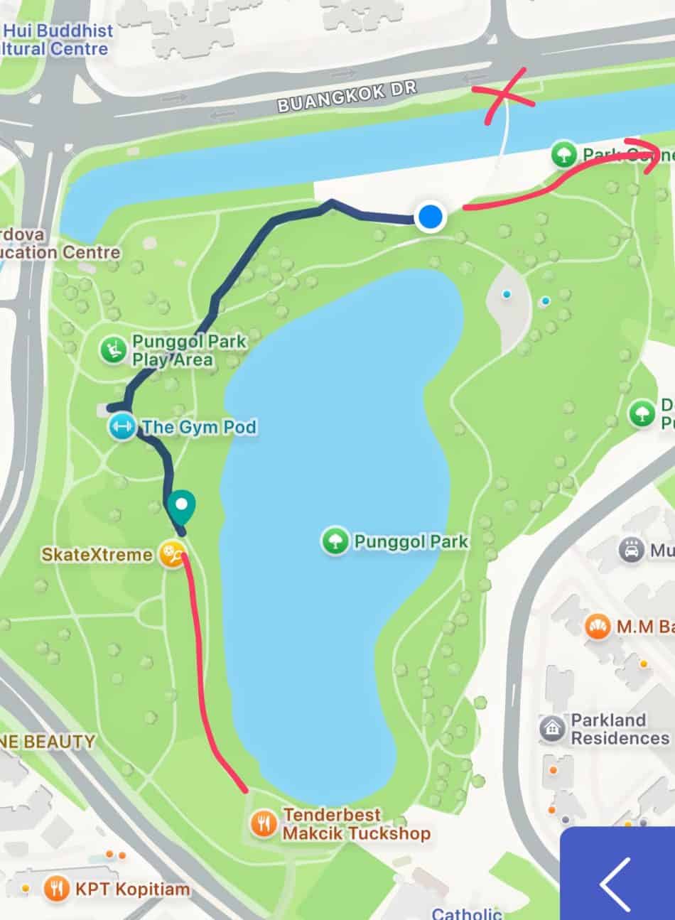
This route below is the one I took to move from Punggol Park to Buangkok Drive. See the cyclist ? That path is inside the park. You just walk that path.

Here’s the path…

You will see all these condos on you left…

And Blk 470B on the right…

And down this path…

Till you see this sign.. which you can then walk under a bridge…

And under the bridge…

You will then see two paths.. one on the left and one on the right…

But we are NOT going to either. In fact, later in the loop we will be COMING FROM the left side…. but for now, turn around and see the bridge we just went UNDER.

This is the bridge we went under that we now want to go over…. so find your way to that bridge. It is just to walk to the left of this photo (and you will see block 477C) and then cross the bridge. You will then come to a very busy road junction.
You will cross the road junction.

You will then cross the road junction to reach to the other side. Riversound Residences is on your left as you cross the road.
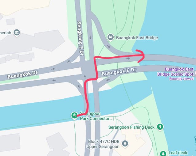
You will then want to cross this bridge…

Beautiful day for a walk..

As you cross the bridge, you can see Buangkok Forest !!

As you approach the end of the bridge, you will see a path on the left to go to Buangkok Forest. The path is blocked at the end of the bridge so you need to jump over the barrier (the area was fenced off for construction, and that you enter at their own risk, ok.. Dont blame me hor…) …..

Yes…. this path.. be a naughty Singaporean okay 😂

This map shows you the way to Getting to Buangkok Forest from Buangkok Bridge
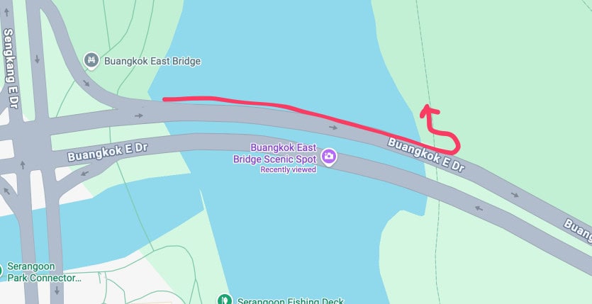
And you will see this. The bridge above your head is, of course, the Buangkok Bridge that you just crossed.

You can probably turn left…. which I guess is where Defu area and if you come from there, you can have a much more complete Buangkok Forest experience ?

But I am turning right today, to start my hike down this part of Buangkok Forest.

Hiking Buangkok Forest
Welcome to Buangkok Forest !!

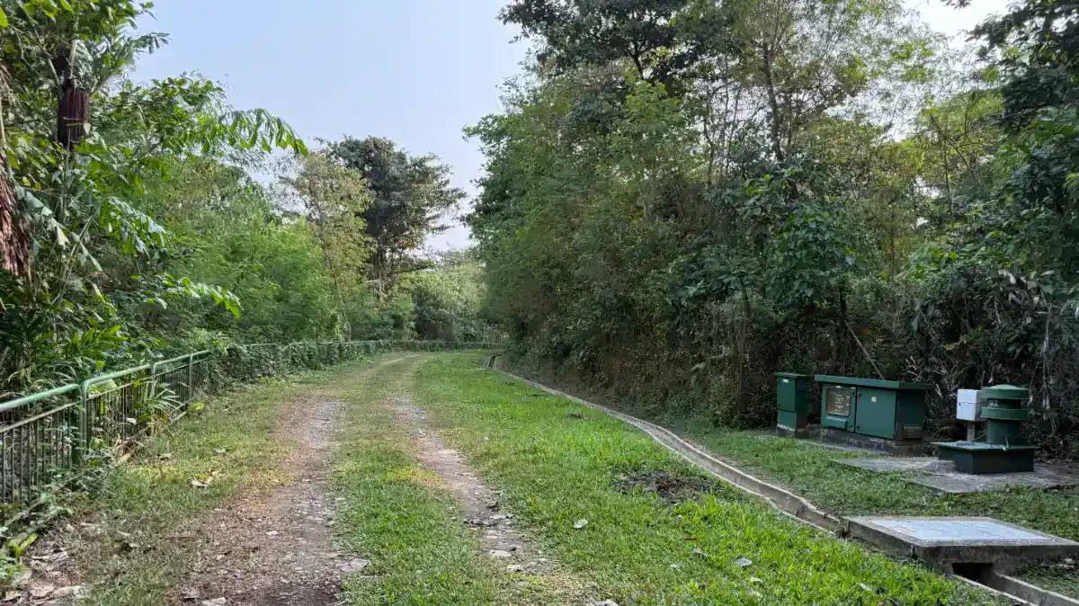
It is a very different hiking route compared to the all the park connectors that we have done together over the years. It is very rustic.. although you get a distinctly two tracks due to all the construction and perhaps maintenance vehicles that went down this way….

With sometimes, big trees to cover your path…

You can see the Punggol HDB flats in the background…

But else it is a VERY NICE NATURAL WALK. Take your time to explore and dont look at your phone lah….


But civilisation is still near … just opposite of Sungei Serangoon 😂

At this, I want to share two advice…
Advice 1 : Muddy Paths
If you come after a rain, you can expect very muddy paths. Even when I was walking after a few day of NO RAIN, there are some parts that are muddy. Of course, you can avoid some but there is one part under a bridge (I will share that later) which you can’t. So come prepared with shoes appropriate for that or bring plastic bags to cover your shoes.

Or don’t come after a heavy rain.
Advice 2: Watch Out for Snakes in Buangkok Forest
Buangkok Forest is wild, and snakes are part of that. Most will slip away long before you notice them, but if you do come across one, stay calm, keep your distance, and back away slowly. Never try to touch, chase, or photograph it up close. Stick to the main trails, wear covered shoes rather than sandals, and watch where you step, especially in thick undergrowth or near fallen logs.
And there is a SNAKE that I met during my hike today. So it is for real. It was a black long snake. Hence, my advice is to walk with a walking stick and pay attention.. dont be obsessed with your phone or camera…
And let’s continue our hike in Buangkok Forest.

After a long walk, you will come to the first bridge. This one no issue… u can walk under it.. I believe this is TPE…..

Just walk to this area

And you will see the part where you can walk under TPE…


If it has been raining, you might want to wear your plastic bags over your shoes here FIRST….. before going under the bridge…. It is even well paved…

Until you look up and see those disgusting nests…

And very muddy path even with no rain for a few days…

And more muddy paths…

And my white shoes….. so smart of me…

So be prepared….
Anyway, continue the hike. The hike continues to be so nice and such a nice experience…

Who cares about muddy shoes…

Hiking in Buangkok Forest : The Slight Detour on Google Map
Now if you look at the walking map on Google Maps, you will see that there is a detour on the way. It is true (not a google map mistake) but it is really not a big deal as you are actually still in the “forest” if that makes sense.
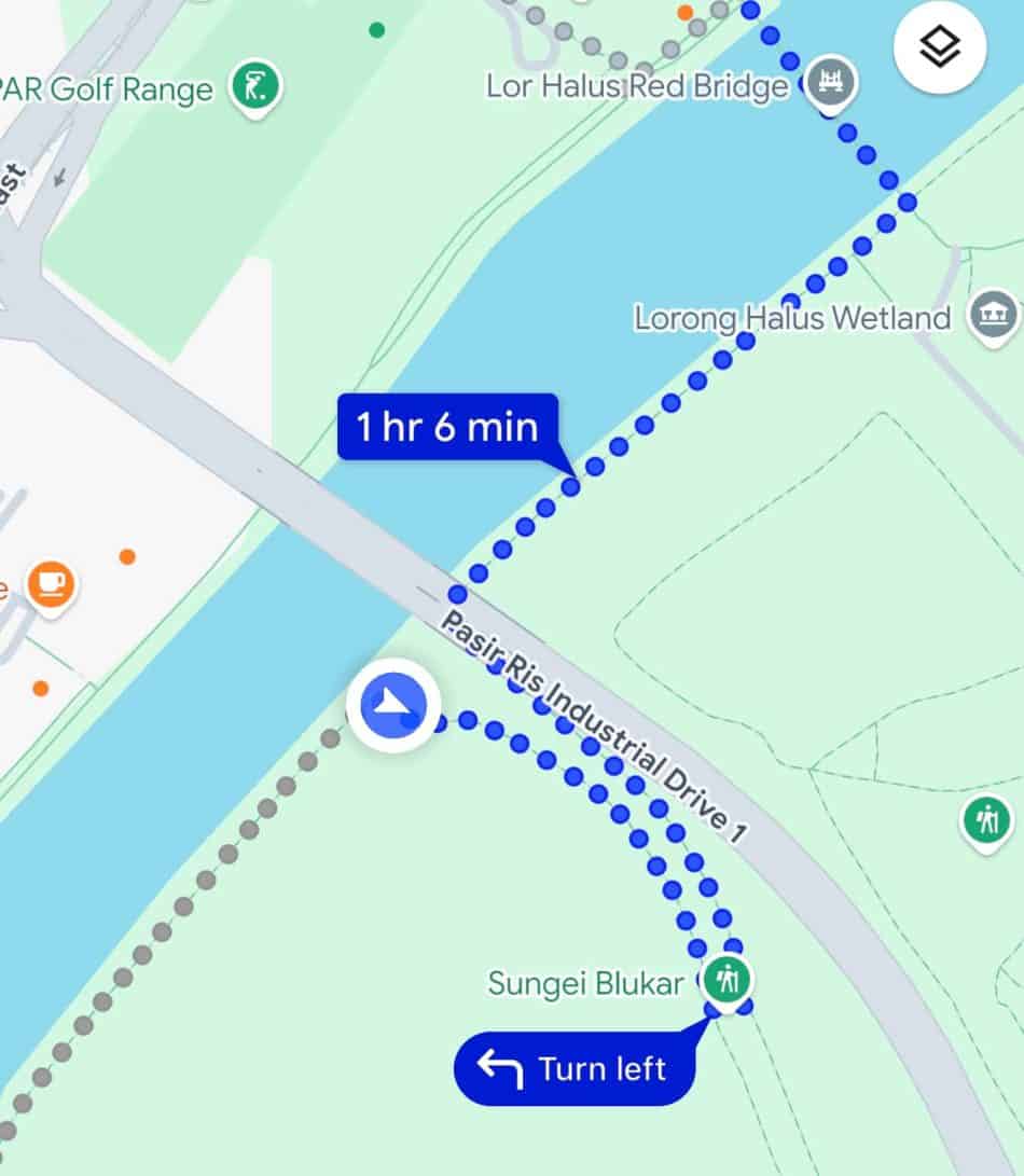
Maybe the photos will let you know what I mean. First you will see this..

You want to cross over to the other side…. there is a river blocking you…

Then you will be turning right….

And the road seemed to go in a different direction….

Until you see construction … damn .. leave our forests alone ! Yes Maju Forest, Clementi Forest and now Buangkok Forest.. how many new citizens you want to bring in !?

But you will see a left turn here… it looks like this… take this turn..

And then turn left again (so you just did a U-turn !).

And soon you will be walking under a bridge.. This is supposedly Pasir Ris Industrial Drive 1….

There is a bridge at the end of this road which I guess you can exit the Buangkok Forest if you want to and get to Pasir Ris…

Looking at Google Map, I guess you can go to a LRT Riviera station from here…
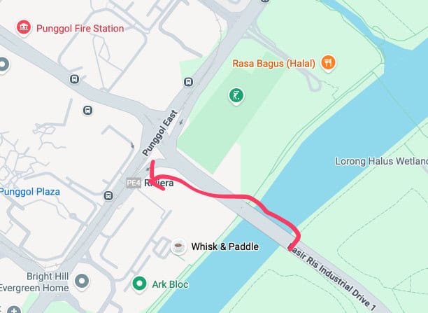
But I am carrying on….. there is a gate here and let’s go on !

And here’s the road.. still looking cool… but you can see the barriers at the end…

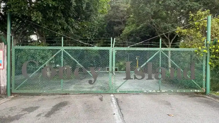
Indeed, when you reached the end of this road, you will have reached Lorong Halus Wetland and yes, the famous Lorong Halus Red Bridge. But we have been here before…… we did that during our hike of Coney Island with our model !!

I love the Lorong Halus Red Bridge !

With the end of Lorong Halus Red Bridge, we would have completed our first part of the hike today. Which is to hike Buangkok Forest. I guess you can end it here if you want to. Or you can walk to Punggol Settlement like we did in the Coney Island hike.
Punggol Promenade Riverside Walk
Technically we are now at Punggol Promenade Riverside Walk…..

To give you a context, here’s a map
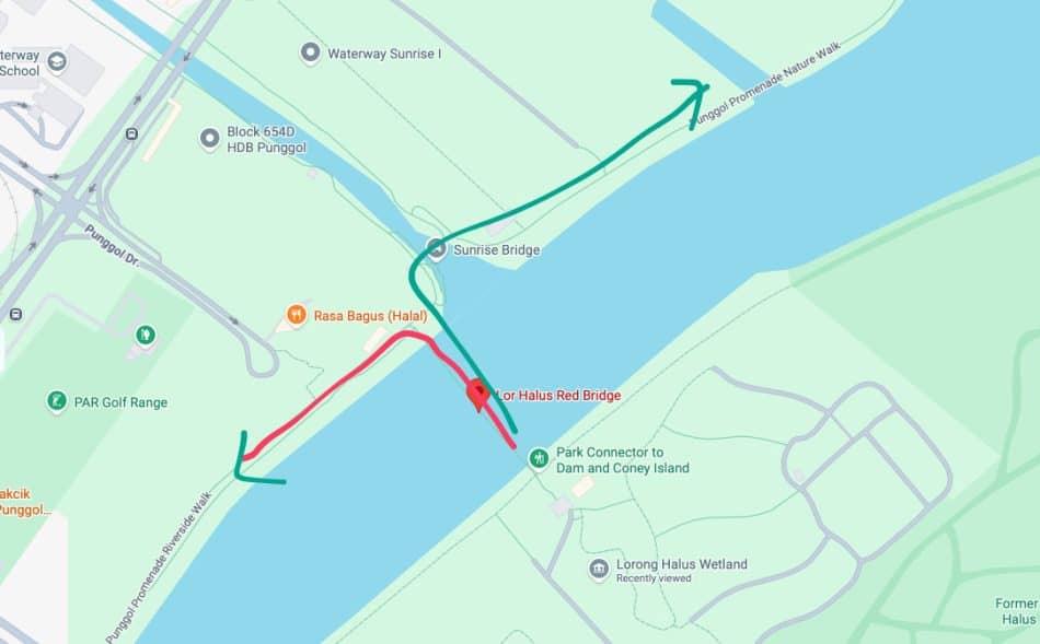
During our Coney Island hike, we took the GREEN route after the Lor Halus Red Bridge. Today I am going to take the red route instead…
Compare to the Buangkok Forest hike, the path is a park connector.. Well paved, well lit, well maintained.. So different….

The red bridge theme continues…

There is a nice toilet with drinks and water cooler almost immediately…

And of course, as you walk along this park connector, you will see the Punggol Container Park which is going away to build new homes for more people as part of the 9.6 million population white paper… SIGH.. you voted for this….


Whisk & Paddle was one nice restaurant I went to before…

There is a scenic spot at this area, where you can see the Buangkok Forest across Sungei Serangoon..

It is also at this point, Punggol Promenade Riverside Walk gives way to Sungei Serangoon Park Connector.
And there is an open field at this area… which I am 100% sure will be used to build more HDB and condos…SIGH….. why do we need so many people…. so that Punggol is more safe for the next election ? 😊

Sungei Serangoon Park Connector to Punggol Park
We are at the last stretch of our hike today. From here, Sungei Serangoon Park Connector, we will walking along Sungei Serangoon (River) to Punggol Park.

But not before checking out some HDB flats that have balconies ! WOW…

I love hiking in that it brings me closer to nature but also sometimes closer to living places such as condos and HDB flats…. for example, my hike Alexandra PCN : A Fantastic Walk of Singapore Progress is a good example.

This is Rivervale Shores HDB area..

There is a coffee shop here so I can’t resist and had my breakfast 😂

Let’s continue our journey to Punggol Park…

As we continue our journey down the Sungei Serangoon Park Connector, you will go under yet another bridge… keep left as you walk here..

See. I promise you another bridge to walk under…

We are then back to the area where we started our journey to Buangkok Forest…

You will then take a RIGHT turn to go back to Punggol Park. The left side leads to a PCN called Serangoon Park Connector.. I will probably explore that area one day !

From here, you are retracing the steps we took this morning and get back to the car park where we parked…

Buangkok Forest and Sungei Serangoon Park Connector : Total Distance
So what is total distance and time to do a loop from Buangkok Forest and Sungei Serangoon Park Connector ?
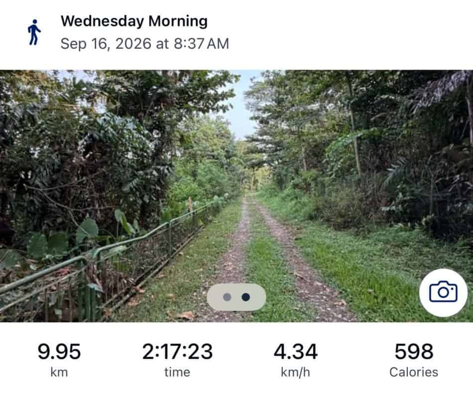
The total distance for a loop around from Punggol Park to Buangkok Forest and then to Punggol Promenade Riverside Walk and back to Punggol Park through Sungei Serangoon Park Connector is 9.95km and it took me 2 hours 17 mins.
Here’s a Runkeeper Map
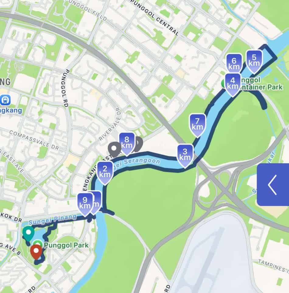
While I did not logged the exact distance for just the Buangkok Forest section, but looking at the Runkeeper map, it was about 4.5 km from the start of Buangkok Bridge to the Lorong Halus Red Bridge.
Buangkok Forest Hike : Conclusion
I would say this is one of my most enjoyable hikes in Singapore due to the rustic nature of the forest hike… really nice and although the black snake gave me a scare, it was never a problem and I love the Buangkok Forest hike !
Buangkok Forest Hike: FAQ
How long is the Buangkok Forest hike?
My full loop from Punggol Park through Buangkok Forest, Punggol Promenade Riverside Walk and Sungei Serangoon Park Connector was 9.95km and took 2 hours 17 minutes. The Buangkok Forest section alone, from Buangkok Bridge to Lorong Halus Red Bridge, is about 4.5km.
Where do I start the Buangkok Forest hike?
I parked at the small car park at Punggol Park, walked through the park to Buangkok Drive, and crossed Buangkok Bridge. The path down to Buangkok Forest is on the left near the end of the bridge.
Is Buangkok Forest muddy?
Yes. Even after a few days without rain, some stretches were muddy, and the section under the TPE can’t be avoided. Wear shoes you don’t mind getting dirty, bring plastic bags to cover them, or skip the hike right after heavy rain.
Are there snakes in Buangkok Forest?
Yes, I came across a long black snake during my hike. Stay on the main trails, watch where you step, keep your distance if you see one, and consider bringing a walking stick.
Are there toilets along the route?
Not inside Buangkok Forest. The nearest toilet, with drinks and a water cooler, is along Punggol Promenade Riverside Walk shortly after Lorong Halus Red Bridge.
Can I exit Buangkok Forest before the end?
Yes. There is a bridge near Pasir Ris Industrial Drive 1 where you can leave the forest and head towards Riviera LRT station.