In my most recent trip to Hong Kong, I did the Hong Kong Dragon Back Hike ! I followed the route all the way but the ending is a little different from the “official” Dragon’s Back hike.
But I highly recommend my ending and you will see why towards the end of this long article !
Table of Contents
About Hong Kong Dragon Back Hike
Nestled in the southeastern corner of Hong Kong Island, the Dragon’s Back mountain ridge trail cuts across Shek O Peak in the Shek O Country Park. The hiking route ascends a gently rising, forested hillside, offering breathtaking views of the lush countryside and craggy coastline from Dragon’s Back Viewing Point. The trail ends beside the white-sand beach of Big Wave Bay. Sections of the part-paved trail feature exposed rocks and knobbly tree roots, providing ample opportunities for Instagram-worthy photos. As you leave the city’s hectic urban landscape behind, checkpoints marked with dragon symbols line the route, guiding you into nature.
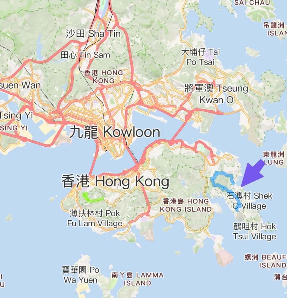
Dragon’s Back is on the eastern end of Hong Kong Island.
What to bring to Dragon’s Back Hike (for Singaporeans)
We don’t hike much in Singapore. We have park connectors and we call it hiking. Hong Kong hiking is more difficult as this is real hills and mountains (not Bukit Timah). It is easy to downplay the hiking in Hong Kong. Don’t. At least not for fat old man like me 🙂
I do suggest leaving your valuables in the hotel and just bring the bare minimum. You might need some cash at the end of the trip for the mini bus but nothing that the Hong Kong Octopus App on your iPhone can’t get you.
Bring a water bottle. Of course. Bring a power bank.
I also STRONGLY RECOMMEND a hiking stick. I don’t care how many times you hiked in Hong Kong or Singapore. You will need a hiking stick. Period. It helped me so much on the trail.

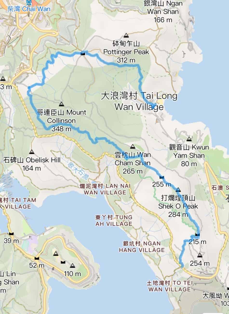
And download this app, Hiking Trail HK. You will find it useful to see where you on the trail (you can pre-save the trail on the app.. it is a famous hike, after all…). And here’s the Dragon Back hiking trail from the app.
Getting to the Start of Dragon’s Back
It is actually very easy to get to the start of Dragon’s Back, although it is a little un-nerving when I arrived at the start of trail, all alone and no one on the bus was going to the same place (I guess that’s because it was on a Monday’s morning).
Anyway as I was staying at the Hong Kong Island hotel (AKI Hong Kong MGallery Hotel), so it was an easy MTR ride from Wan Chai to Shau Kei Wan Station.

Then exit the MTR station at A3 exit to the “bus terminal” (bus interchange, Singaporean term).

Find the standalone bus stop in the terminal for Bus 9.

This is the BUS STOP for Bus 9.

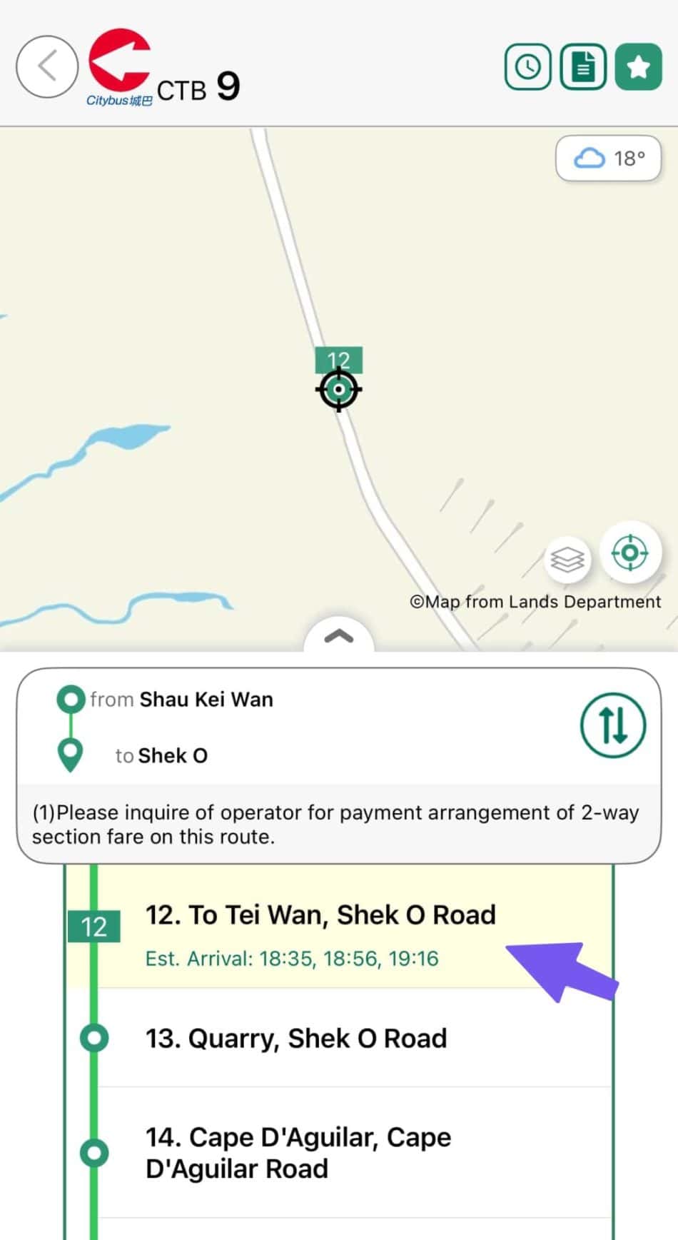
Take bus 9 from Shau Kei Wan Bus Terminus to To Tei Wan, Dragon’s Back stop on Shek O Road. That would be Bus Stop number 12 on the ride.
This is the nice bus….

Here’s the bus route from start to the bus stop we need…


The bus stop we want is BUS STOP 12 (To Tie Wan)
Don’t worry. There is an electronic sign at the front of the bus to tell you the stops. I try my best to take the photos (without losing the stop).


Very important : In many blog posts, they said don’t worry, many other hikes will be going to the same place so you don’t have worry. Nonsense. It all depends on when you go. I went on a Monday morning at 7:30am and I am the only one ! So You Do Need To Watch Out.
If you are right, you will be at this sign when you get off the bus. Else best of luck 🙂

There are toilets at this place so use it before you start the hike. There is also a nice map.

But here’s a clearer one for you (but you should be using the app)…. You are now at Number 1 on the map. Note that we will from (1) to (5) but not from (5) to (6)
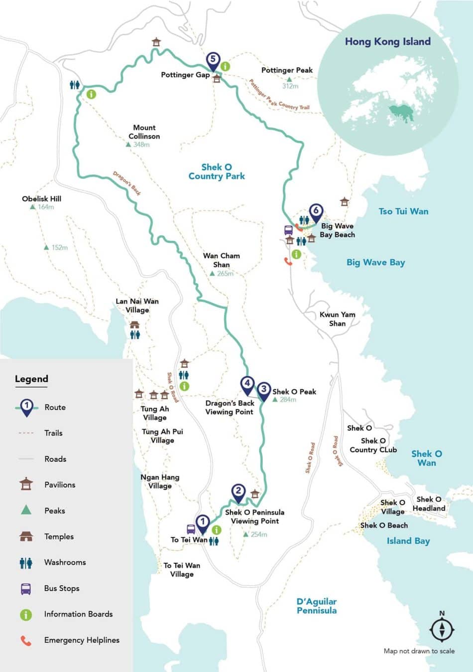
The Hong Kong Dragon Back Hike
Beautiful scenery many many along the way. Just enjoy the walk (with your hiking stick !).
The starting point looks interesting 🙂

And then..

Pace yourself.. Don’t Chiong hor… Like this type of steps.. Slowly..

Views like this is everywhere… Enjoy your hike..

Signs like this as everywhere to help you. When in doubt (doubt so.. but since we are blur blur Singaporeans), then use the App and its GPS functionality. Frankly there is NO way you can get lost…

And if you are using the app, the app will show you where you are (RED ARROW in this image) and the way forward in green. HOW TO GET LOST 🙂
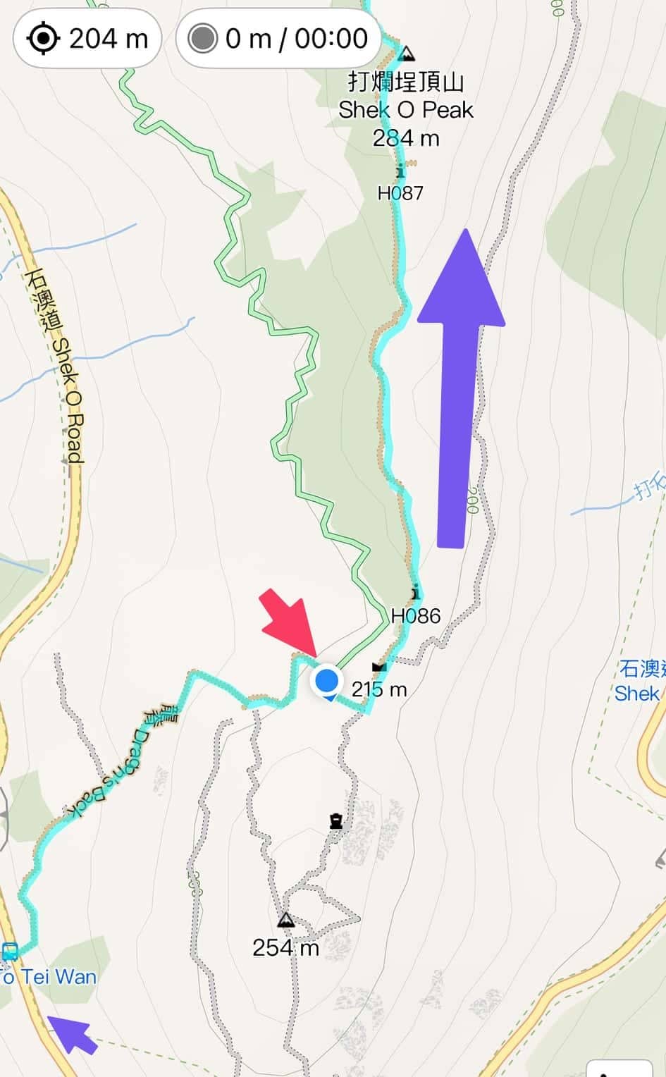
And also I love this “Distance Post” waypoints… the app will also show them…

Shek O Peninsula Viewing Point
There are many places to take photos too.. e.g. Shek O Peninsula Viewing Point

Views…

Dragon’s Back as you walking along the dragon back of the mountain….

Shek O Peak Elevation Point
At the top of the dragon back .. Shek O Peak Elevation 284metre.

The marker at the summit.. just like what we saw at Scenic Hill hike. Official name is triangulation station (Many trigonometrical stations were placed on hilltops around Hong Kong. They strongly resemble those used in other former British colonial territories such as Australia, consisting of a white column topped with a black band)

Take a break here.. nice bench with nice views..


And now we continue the hike.. look at the route along the dragon back !

Regular checking of the app tells you that you are okay and the route ahead…

Cool !

The views and the route…

I really enjoy looking AHEAD at the route forward.. along the Dragon’s Back.. For Feng Shui !

The route we have covered so far… you can see we have passed H090 and almost reaching H091 and H092…. I am not showing many photos but it is a DAMN NICE WALK !!!

Reaching H093
Unfortunately, the fun ends when you reach Point H093….

It is more “urban” now..

At this point, you want to go to Big Wave Bay.. not the left turn but the right turn..

On the app, you can see we are doing a RIGHT turn on the H094…

Yes.. don’t worry.. carry on ! Dragon Back is over.. ha ha..

You are now walking along concrete roads..

Reaching H095
Reaching H095, you will find a rest point. with pretty nice views..


Views at H095 Rest Area

Did I ask you to bring some Snickers Bars 🙂

Reaching Pottinger Gap Rest Point
A further walk and you will reach the Pottinger Gap. Pottinger Gap refers to a location in Hong Kong where multiple hiking trails converge, including the famous Hong Kong Trail Section 8. It is an area at the base of Mount Collinson known for its open rest area with benches and a pavilion, serving as a junction for trails leading to Big Wave Bay and Chai Wan.

At this point, there is a rest point…

This is also the Point where we are going to NOT use the official Hong Kong Dragon Back Hike path but go to another path.
A new finishing route from Pottinger Point to Big Wave Bay Beach
Let me explain… The Red Line on this app showed the normal way the Dragon’s Back hike will be… the left image is from the App (we are the blue dot) and the right is from Hong Kong Tourism Board. ha ha…

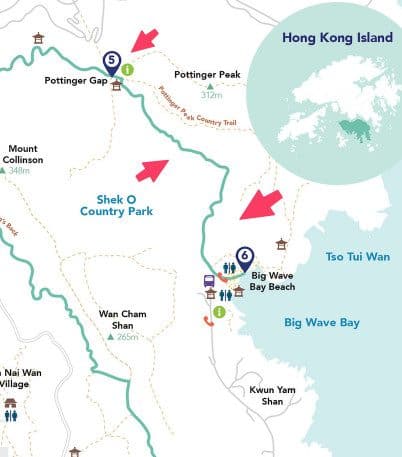
This route is fine ! If you want to, do it. But a local lady told me to go to the YELLOW route (on the left image, the YELLOW line). which will still reach Big Wave Bay !
So let’s go.. from the rest point, walk straight on..

A very short walk later, you will see this sign…

You will take this route to To Big Wave Bay by the original route.

However, since we are “adventure seeking” Singaporeans (ya, right), we are NOT going to turn right here. Instead we are going straight… The new route we are taking to Big Wave Bay…. Just to be clear, we are still going to Big Wave Bay. Just a slightly different way….
Like this..

Like this..

Like this..


On the app (see, I told you the app is good), we are now on the YELLOW route (The new route we are taking from Pottinger Gap to Big Wave Bay) and going to go for C4201 and C4202.

Watch out for this C4201

And then C4202 where we will need to slow down to find the right route to Big Wave Bay…

Pottinger Point to Big Wave Bay Beach : A different Route
We are going past C4202 and turn right down the new path to Big Wave Bay..

You will see this signboard…. you will see the bench, that’s where you are going to.. that means turn right at this signboard…

You should see this sign after turning right..

A nice path ahead… well maintained ! Hong Kong rocks…

Another nice rest point…

And you will see why we took this route.. The views DOWN from Hong Kong Dragon Back Hike to Big Wave Bay is so good along this way as it is right along the coast !!


If you are still using the app, this is what you should see

Hello Big Wave Bay !

The views along this route is worth the walk…. I can say that the Hong Kong Dragon Back Hike is much better with this new route !

Another rest point called 大浪亭

Reaching Big Wave Bay

Hello Big Wave Bay….

The Big Wave Bay Beach !

Welcome to Big Wave Bay, the ending point of my Hong Kong Dragon Back Hike

Total Distance from Start of Dragon’s Back to Big Wave Bay
….. Is 8km….

It took me 2hours 40mins to walk from Start of Dragon’s Back to Big Wave Bay

Mini Bus back to Shau Kei Wan
From the Big Wave Bay, it is just a short walk to this bus stop for city buses and mini buses to Shau Kei Wan MTR.
Yes Bus 9 again.. but this time at Big wave bay 🙂


But why take a bus when there is my favourite mini buses ! Try the mini bus !

Here it comes !

Conclusion of Hong Kong Dragon Back Hike
To do or not to do ?
Of course do it !
Especially with the slightly different ending of the Dragon’s Back hike where you have great views !


